Community Science
Community Science for above-ground carbon verification
Our NASA-funded project combines community-based science with cutting-edge satellite remote sensing to better understand how forests store carbon and to make sure the communities living in those forests are part of the science. While NASA missions such as GEDI (Global Ecosystem Dynamics Investigation) provide the most detailed space-based measurements of forest height and biomass ever collected, many regions of the world still lack on-the-ground data needed to validate and improve these products, especially in the tropical Global South, where field campaigns are rare. This lack of representation means that some of the most biodiverse and carbon-rich forests on Earth are also the least verified in global models.
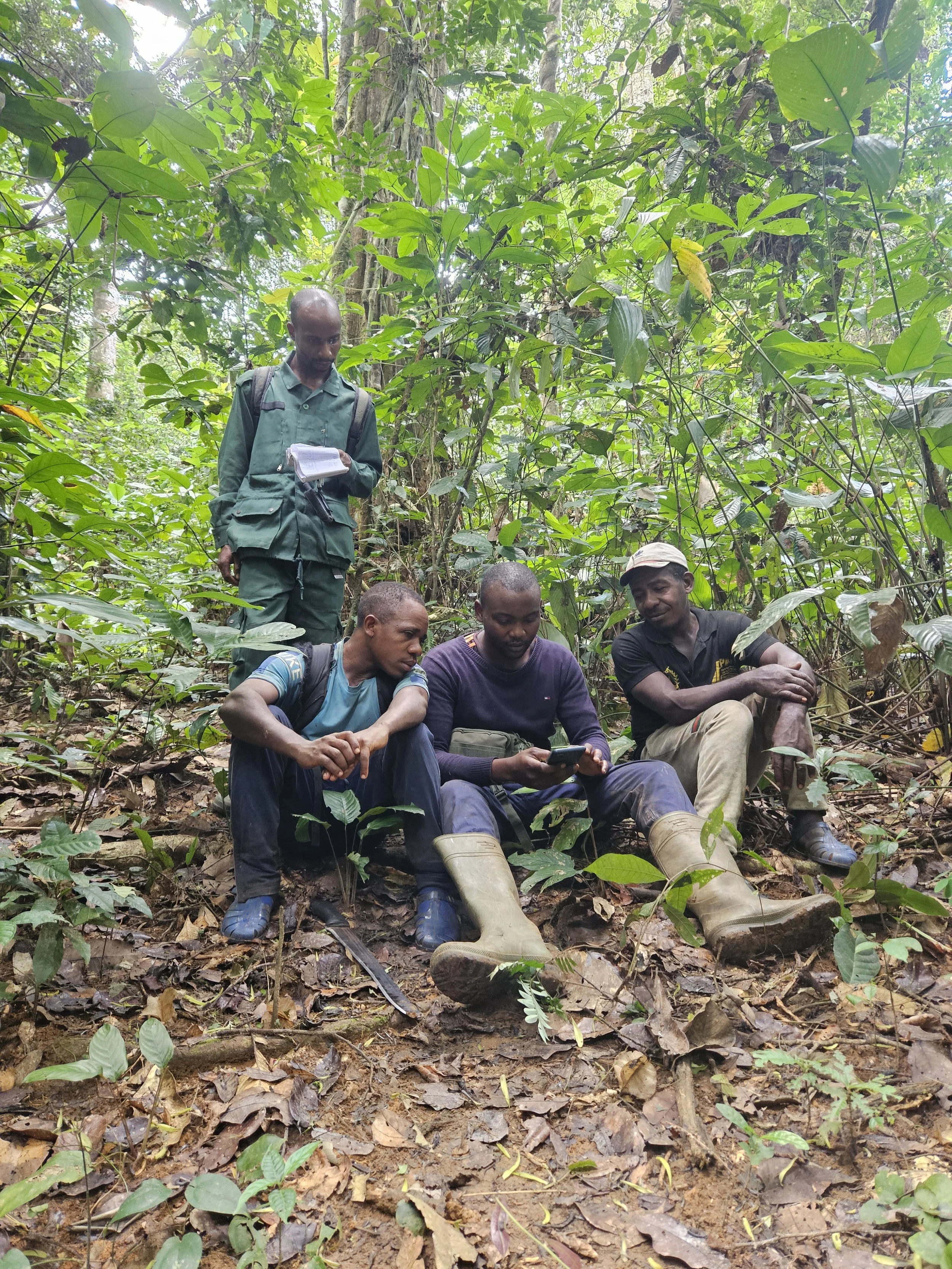
Our project addresses this gap by working directly with students, teachers, Indigenous Peoples and Local Communities (IPLCs), and after-school programs to collect tree height, diameter (DBH), and species data using the GLOBE Observer “Trees” protocol. Each data point is linked to a real satellite footprint from NASA’s GEDI mission, allowing us to build high-quality “ground truth” datasets that strengthen biomass estimates in places where satellite-only data is most uncertain. These measurements not only improve NASA’s global carbon maps, but also create a public dataset that is usable by local communities, educators, and researchers around the world.
Beyond the scientific impact, this project is also about equity in environmental monitoring. The majority of global forest data used in climate research is collected in high-income countries, yet the consequences of climate change fall disproportionately on the communities least represented in scientific datasets. By co-designing data collection with IPLCs and educators in Kenya, Ecuador, and the United States, we are building a model for community-centered science that respects local knowledge, identifies motivations and barriers to participation, and ensures that the information created is useful not only to NASA, but also to the people who live in and depend on these ecosystems. The long-term goal is not just to improve biomass science, but to reshape who gets to contribute to (and benefit from) Earth science research.

Current Pilot Sites & Community Engagement
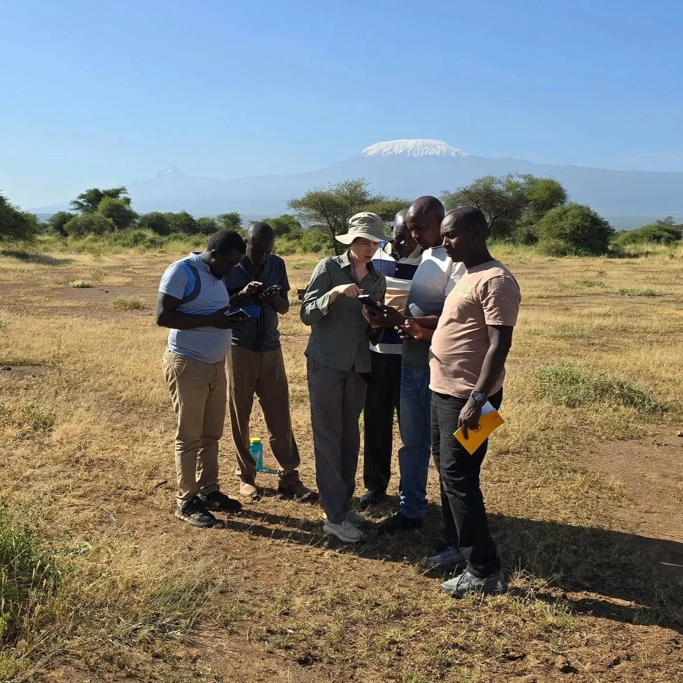
Southern Kenya – partnering with Maasai communities, schools, and conservation networks to understand motivations, barriers, and benefits of citizen science participation.
Flagstaff, Arizona (USA) – working with local classrooms and youth organizations to test field protocols and develop training materials that can be used globally.
In 2025, our team led a packed workshop at the GLOBE Biennial Conference, teaching educators and citizen scientists how to collect tree data and connect it to NASA satellite missions. We are currently expanding outreach to schools, after-school STEM programs, and community groups in Kenya, Ecuador, Malaysian Borneo, and across the United States.
Want to Get Involved?
We are actively looking for schools, youth groups, NGOs, and educators interested in bringing this project to their community. Whether you have a forest, a schoolyard tree, or just curiosity, you can contribute meaningful data to NASA’s global database—and help shape how forests are monitored and protected worldwide.
Educators & community partners: Contact us if you’d like our team to lead a workshop or visit your school
Community carnivore monitoring
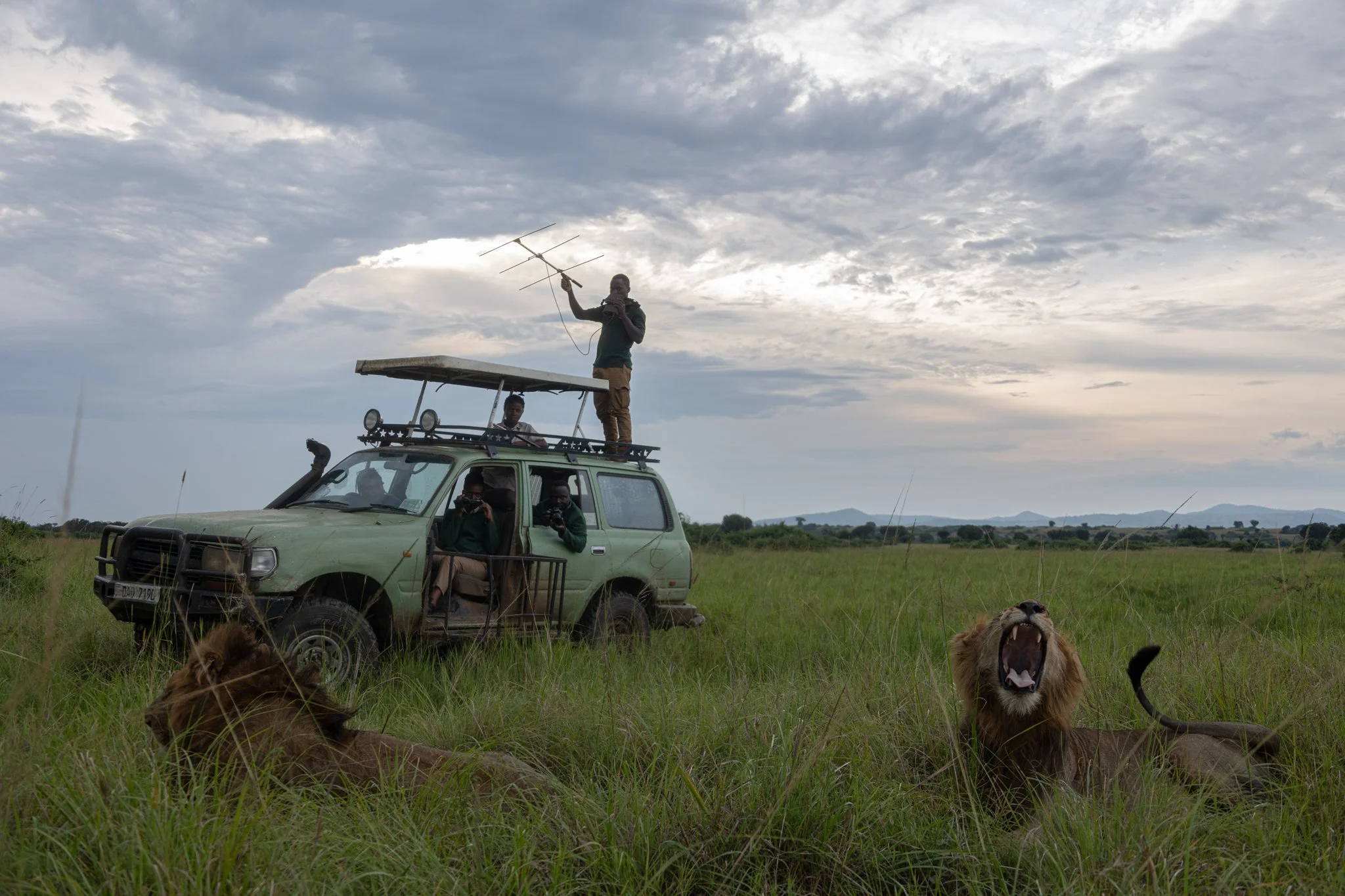
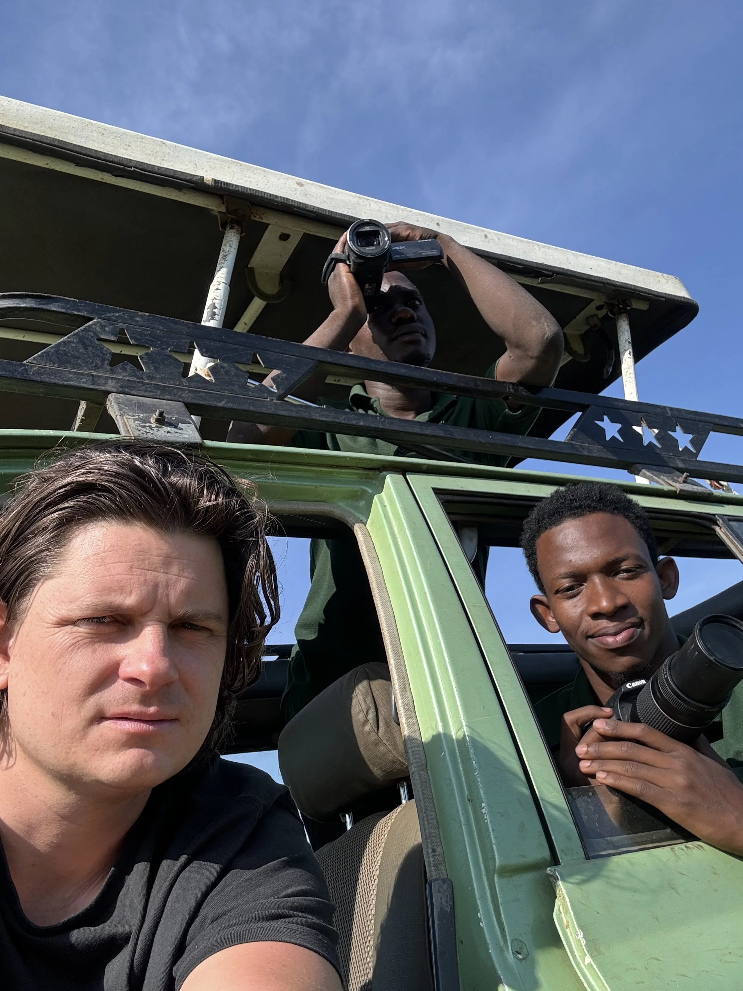
Large carnivores such as Lions draw enormous public attention globally and are flagships for extensive conservation funding. However, the involvement of communities that bear the costs of living with carnivores such as lions are often limited, and they receive few benefits. An initiative led by Alex Braczcowski in Uganda is trying to reverse this. The initiative involves getting local rangers, and community members actively involved in carnivore monitoring.
Since 2022, Duan Biggs, the Olajos Goslow Chair at Northern Arizona University has provided critical co-funding to this project which first led to the creation of a national-level census of African lions, leopards, and spotted hyenas across six protected areas in Uganda (Kidepo Valley National Park, Pian Upe Wildlife Reserve, Murchison Falls National Park, Toro Semliki Wildlife Reserve, Queen Elizabeth National Park, and Lake Mburo National Park).
This extensive logistical effort included over 100 Ugandan wildlife authority staff, and collaboration with hunters, tourism guides, lodge owners and rangers. Cutting edge capture recapture statistics supported this endeavour. Numerous workshops were held to train and develop skills among the diversity of team members.
This initiative led to the creation of the VSPT Kyambura lion programme which permanently employs six field staff to permanently monitor and census these species in the Queen Elizabeth National Park - the home of Ugandas iconic tree-climbing lions. Ultimately this initiative aims to foster the capacity that will enable the continuous monitoring and data feeding to the government which will facilitate timely conservation and management actions for lions and other carnivores. The projects members have also been involved in critical science communication work leading to the documentation of world first long-distance swimming behaviour by African lions.
Fairness is a cornerstone of our work
We recognize that for community science to succeed, participants must be valued and rewarded for their contributions. To achieve this, we focus on:
Capacity Building: We provide opportunities for community scientists to build scientific skills and knowledge. This educational aspect equips participants with the tools they need to understand and interpret the data they collect, and to engage in meaningful discussions about local biodiversity conservation.
Empowerment and Advocacy: Empowering community scientists means not just collecting data but giving them access to information that allows them to voice their concerns and leverage their interests. From the onset of our projects, we ensure that the data collected is useful for local advocacy and decision-making.
Fair and Secure Compensation: We are exploring ways to reward citizen scientists through financial incentives, in line with funds allocated for conservation efforts under international agreements such as the CBD. This requires careful work on designing fair, secure, and equitable payment systems within the socio-economic context of each region. By doing so, we aim to create systems that are both sustainable and beneficial to local communities.
Through community science, we aim to build a future where local knowledge and global technologies work hand-in-hand to protect biodiversity and ensure that conservation efforts are both effective and equitable.
Community Science for Conservation and Biodiversity Monitoring
The conservation sector has committed itself to enhancing inclusivity and equity in achieving conservation goals. These commitments are enshrined in agreements such as the Kunming Montreal Global Biodiversity Framework of the Convention on Biological Diversity (CBD). Despite these commitments, where the rubber hits the road in conservation in the global south, much work is still to be done.
Our lab is committed to enhancing the role of community science in conservation through a focus on fairness and inclusivity. Our approach is grounded in ensuring that community scientists are both valued contributors and direct beneficiaries of the projects they engage in.
We strive towards effectiveness and inclusivity
Our team works on creating frameworks and solutions making it easier for community members to actively participate in scientific research. These efforts include:
Embedding Community Scientists: We work on creating pathways for embedding community scientists within research projects. This means involving them from project conception to the analysis and application of findings.
Improving Engagement with Technology: We are contributing to dedicated community science apps to enhance community scientists' engagement by providing them with user-friendly tools to collect, analyze, and share data. This helps lower the barriers to participation and fosters real-time collaboration, which we further strengthen through on the ground local engagement (e.g. workshops, trainings).
Synergizing Ground Observations with Remote Sensing: In synergy with remote sensing technologies (e.g. satellite imagery), we ensure that the data collected by community scientists complements and enhances high-level ecological monitoring. This integration allows for a richer, multi-scale view of ecosystems and biodiversity changes.
References
Gaillard, C., Keany, J.M., Biggs, D., et al. Mobile apps for 30×30 equity. Nat Sustain 7, 683–684 (2024). https://doi.org/10.1038/s41893-024-01309-7